
Best trips in Lofoten

In the first article, as always, I went through the practical details, and now let’s take a look at the places we enjoyed – places I can, with a clear conscience, recommend to those of you planning a trip to this enchanting archipelago. When planning your trip, I suggest you research thoroughly what you want to see, so you don’t end up rushing frantically back and forth. At the same time, set your priorities and slot them into your daily itinerary according to the current weather – in other words, if the sun’s shining, go and climb a hill, because just because it’s shining now doesn’t mean it will be tomorrow.
With the children, we certainly didn’t have any ambitions to climb all the viewpoints and peaks; on the contrary, as always, I tried to strike a balance. Fortunately, there are plenty of beautiful spots in the Lofoten Islands that don’t require too much effort. You drive there, park up and stroll amongst those divine little red houses, enjoy a cinnamon bun whilst looking out over the harbour, and simply ‘be’. In the following lines, I’ll put together a mix of everything from hikes and beaches to fishing villages in the western part of the Lofoten Islands. To finish off, I’ll add a few places to stop along the route from the airport to the island of Vestvågøya (Evenes–Leknes), which will come in handy to break up this roughly four-hour journey.


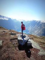
- Innersand (7 km) - probably the most popular route, mainly thanks to the large car park and the option of taking a detour to the iconic Ryten (add 3 km). This is the hill with the boulder that looks as though it’s suspended at a staggering height, but in reality there’s a platform right beneath it from which you can ‘jump’ onto it. The downside of this starting point is the charge for parking (100 NOK for a car, 150 NOK for a campervan); the upside is the availability of refreshments.
- Torsfjord (4,6 km) - we chose this one because of its length, plus there was free parking; however, the number of spaces here is quite limited and only for cars. We liked the route itself (see photos), although of course it goes up and down – and the same way back again. Nina walked the whole way on her own two feet, whilst Jony enjoyed hopping over rocks and walking along the wooden footbridges, though he did spend a bit of time lazing about in his baby carrier too. The whole trip, including our time on the beach (photos, sandcastles, chasing seagulls…), took us just under four hours.
- Markjorda (9,6 km) - I haven’t tried this option myself, but it seems like a good place to start, even if you want to do a loop. Parking here should also be free.


 |
 |


|
 |
2. Volandstind - wherever you set off from to reach Kvalvika beach, you’ll pass the conical mountain Volandstind, which looks like a shark’s fin. You can, of course, climb to the top of it and enjoy the view, but the view from below isn’t half bad either. In my opinion, the best view opens up right from the Flakstadbruene bridge, which is reminiscent of the Atlantic Ocean Road. You might recognise it from a James Bond film, or perhaps not – either way, there’s no doubt it’s incredibly photogenic.


|
 |
3. Ramberg beach - the complete opposite of Kvalvika, because you won’t have to lift a finger here. Ramberg is situated in the village of the same name and, at first glance, looks just like a Caribbean beach. The sand is incredibly light in colour and contrasts beautifully with the clear blue water. Unfortunately, it’s also quite icy. Nevertheless, the children really enjoyed it here – they looked for shells and paddled around, at least up to their ankles. Just watch out for jellyfish!


|
 |

4. Nusfjord - one of the best-preserved fishing villages in the Lofoten Islands, which serves as a living open-air museum. Naturally, there are the traditional red rorbu cottages, most of which are rented out to tourists, plus a few buildings painted yellow for a change (warehouses, a gallery, a café and more). We can wholeheartedly recommend the Landhandleriet Café in particular; it has a beautiful interior and a tempting menu. Parking is free, but there’s an admission charge of 100 NOK per adult to enter the open-air museum. However… we arrived in the late afternoon and there was no one left to collect the fee.
 |
 |


|
 |


 |
 |
5. Hamnøy - let’s now gradually make our way further west… Hamnøy is likely to be something of a must-see stop, as this is where you’ll find one of the most iconic Lofoten views: the typical red houses with the mountain peaks rising behind them. I recommend parking at the free Parking Hamnøy viewpoint car park (Google Maps) and then walking over to the village, ideally stopping off at the tiny Eliassen Bakery. And you’ll get the best photos from the bridge, which you’ll then cross to continue on your way...


|
 |

6. Reine - probably the most famous little town in the Lofoten Islands. The one you’ll read about everywhere – and also the one that, personally, didn’t really do anything for me at all. Want to know why? Because this is the starting point for the Reinebringen viewpoint, which most people have pigeonholed as ‘if you don’t climb it, you haven’t been to the Lofoten Islands’. And to be honest, I’d originally planned to do this hike too, until I saw IT. To give you an idea, at all the places we visited on this beautiful archipelago, there were just a few cars and a few people, but this… pure horror and dread, chaos and crowds of people. Just imagining what it might be like on the way up – or at the top – made me feel queasy, so in the end we had an ice cream in the harbour, took a few photos and made a quick getaway.


|
 |
7. Sørvågen Falls - A pleasant walk with views of the lake and, at the end, a cascading waterfall – a real balm for the soul after the crowds in Reine. The round trip is only about 1.5 km, but we enjoyed a picnic there – there are several benches and tables available, and the children had fun climbing on the rocks and testing the water temperature by the waterfall. Of course, from here you can continue further along the Munkebu Trail, or you can walk all the way round the lake. The nearest starting point is the paid car park (60 NOK for 4 hours) at the end of the village of Sørvågen, which also serves as the starting point for the climb to the summit of Tindstinden.


|
 |
8. Å - Well, ladies and gentlemen, this is the westernmost and, at the same time, the southernmost point you can reach by car in the Lofoten Islands. It is in this tiny fishing village that the road ends; you simply can’t go any further by car. You can park for free in the large car park here, from where you just walk down amongst the red rorbu cottages perched above the water. In Å, you can visit the Norwegian Fishing Village Museum – tickets cost 155 NOK for adults and can be bought at the information centre, and you can explore several buildings at your own pace (more info here). There’s also the renowned Bakeriet på Å bakery, which boasts a working stone oven dating from 1878.


 |
 |
And one thing you definitely can’t miss here is the fish-drying racks – known as ‘hjell’. Drying fish is a typical practice in the Lofoten Islands, as the conditions here are absolutely ideal: it’s neither too hot nor too cold, and the wind helps ensure the fish are dried properly. But take note! They aren’t hung up here all year round. The main catch here is cod – skrei – whose shoals migrate to warmer waters to spawn during the winter months (roughly January to March). The fishermen gut the caught fish and usually tie them in pairs by their tails. They are then hung over wooden racks, where they remain for 2–3 months. This season is said to peak at the end of June, but this year there weren’t many to be seen even at the start of the month.
 |
 |
 |
 |

9. Nonstinden - For the last two stops, we’ll head back to the island of Vestvågøya, with its main town of Leknes – the place from which we set off each time from our accommodation in Stamsund. The peak of Nonstinden towers above the little town of Ballstad at a height of 459 metres, and it was one of our most beautiful trips ever. Those views! Absolutely incredible – truly magnificent. What’s more, there were hardly any people there, and as an added bonus, it was completely free, as there’s no charge for parking.


|

|


Enter ‘Ballstad, Kræmmervikveien’ into your sat-nav as your starting point; on mapy.cz you’ll see a marked car park (these aren’t shown on Google Maps!). There are plenty of ways to get up there. There aren’t any signposts there, but there are well-trodden paths, and you can check the direction on the maps mentioned above. I’ve attached a map showing roughly the route we took; in total, this circular walk is about 5 km and… you certainly won’t regret it!


 |
 |


You certainly won’t get bored in the outdoor part of the exhibition either. You can have a look at – or even take a trip on – a real Viking ship, play Viking games, or perhaps try your hand at axe throwing or archery. The little ones will, of course, be drawn to the grazing horses, cows and piglets. Admission for adults is 265 NOK; children under 6 go free, and parking is free. Prices drop slightly outside the peak season – for example, at the end of September, admission is just 210 NOK. In any case, you can find full details on the official website here.


 |
 |


|
 |


|
 |
Stops along the route on the island Austvågsøya


|
 |
2. Svolvær - one of the larger towns in the Lofoten Islands, where you’ll also find the odd restaurant; it’s also an ideal starting point for hikes. I’d originally planned to hike at least a short way towards a viewpoint called Svolværgeita, but there was such a nasty gale blowing here that it simply wasn’t feasible. The other popular hill above the town is Fløya and the photogenic rock formation Djevelporten, so I’ll keep my fingers crossed that you’ll have better weather :)

3. Vågan kirke - also known as the Lofoten Cathedral due to its size, this wooden church in Kabelvåg will immediately catch your eye with its yellow colour. Or perhaps because it stands right by the road, opposite the car park, so you don’t have to drive anywhere...


|
 |




Žádné komentáře: